


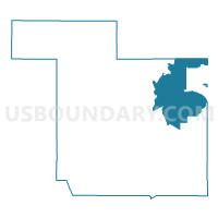
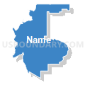
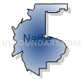
Sandoval County Precinct 79, Sandoval County, New Mexico
About
Outline

Summary
| Unique Area Identifier | 623965 |
| Name | Sandoval County Precinct 79 |
| County | Sandoval County |
| State | New Mexico |
| Area (square miles) | 327.67 |
| Land Area (square miles) | 327.65 |
| Water Area (square miles) | 0.03 |
| % of Land Area | 99.99 |
| % of Water Area | 0.01 |
| Latitude of the Internal Point | 35.80416620 |
| Longtitude of the Internal Point | -106.44986720 |
Maps


Graphs
Select a template below for downloading or customizing gragh for Sandoval County Precinct 79, Sandoval County, New Mexico


Neighbors
Neighoring Voting District (by Name) Neighboring Voting District on the Map
- Los Alamos County Precinct 1, Los Alamos County, NM
- Los Alamos County Precinct 11, Los Alamos County, NM
- Los Alamos County Precinct 14, Los Alamos County, NM
- Los Alamos County Precinct 16, Los Alamos County, NM
- Rio Arriba County Precinct 27, Rio Arriba County, NM
- Rio Arriba County Precinct 7, Rio Arriba County, NM
- Sandoval County Precinct 10, Sandoval County, NM
- Sandoval County Precinct 16, Sandoval County, NM
- Sandoval County Precinct 18, Sandoval County, NM
- Sandoval County Precinct 20, Sandoval County, NM
- Sandoval County Precinct 7, Sandoval County, NM
- Sandoval County Precinct 78, Sandoval County, NM
- Sandoval County Precinct 8, Sandoval County, NM
Top 10 Neighboring County Subdivision (by Population) Neighboring County Subdivision on the Map
- Los Alamos CCD, Los Alamos County, NM (12,213)
- South Rio Arriba CCD, Rio Arriba County, NM (9,344)
- Santo Domingo-San Felipe CCD, Sandoval County, NM (8,270)
- Santa Clara Pueblo CCD, Rio Arriba County, NM (7,902)
- White Rock CCD, Los Alamos County, NM (5,737)
- Jemez-Zia CCD, Sandoval County, NM (4,544)
- Coyote CCD, Rio Arriba County, NM (1,288)
Top 10 Neighboring Unified School District (by Population) Neighboring Unified School District on the Map
- Española Municipal Schools, NM (36,634)
- Bernalillo Public Schools, NM (24,342)
- Los Alamos Public Schools, NM (17,950)
- Jemez Valley Public Schools, NM (5,273)
- Jemez Mountain Public Schools, NM (1,510)
Top 10 Neighboring State Legislative District Lower Chamber (by Population) Neighboring State Legislative District Lower Chamber on the Map
- State House District 43, NM (27,235)
- State House District 65, NM (26,930)
- State House District 41, NM (23,742)
Top 10 Neighboring State Legislative District Upper Chamber (by Population) Neighboring State Legislative District Upper Chamber on the Map
- State Senate District 22, NM (60,988)
- State Senate District 39, NM (48,118)
- State Senate District 5, NM (44,454)
Top 10 Neighboring 111th Congressional District (by Population) Neighboring 111th Congressional District on the Map
Top 10 Neighboring Census Tract (by Population) Neighboring Census Tract on the Map
- Census Tract 3, Rio Arriba County, NM (6,957)
- Census Tract 5, Los Alamos County, NM (5,737)
- Census Tract 2, Los Alamos County, NM (5,057)
- Census Tract 4, Rio Arriba County, NM (4,766)
- Census Tract 9408, Rio Arriba County, NM (4,448)
- Census Tract 1, Los Alamos County, NM (3,839)
- Census Tract 9402, Sandoval County, NM (3,566)
- Census Tract 112, Sandoval County, NM (2,729)
- Census Tract 110, Sandoval County, NM (1,963)
Top 10 Neighboring 5-Digit ZIP Code Tabulation Area (by Population) Neighboring 5-Digit ZIP Code Tabulation Area on the Map
- 87532, NM (18,223)
- 87544, NM (17,950)
- 87537, NM (2,957)
- 87025, NM (1,237)
- 87041, NM (881)
- 87072, NM (660)
- 87044, NM (387)